
Fajl:Italy 1494 AD.png

Nav dijə kardej pamjə: 419 × 600 piksel. Čo iznon: 168 × 240 piksel | 335 × 480 piksel | 536 × 768 piksel | 1,261 × 1,805 piksel.
Ce fajli original (1,261 × 1,805 пиксел, фајли памјә: 144 KB, MIME тиспир: image/png)


|
File:Italy 1494 AD-it.svg is a vector version of this file. It should be used in place of this PNG file when not inferior.
File:Italy 1494 AD.png → File:Italy 1494 AD-it.svg
For more information, see Help:SVG. |
 |
Xylosə
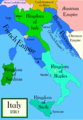
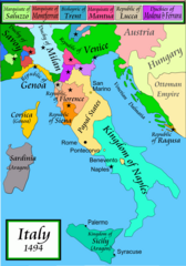
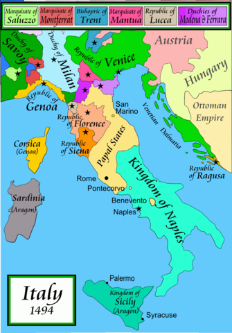
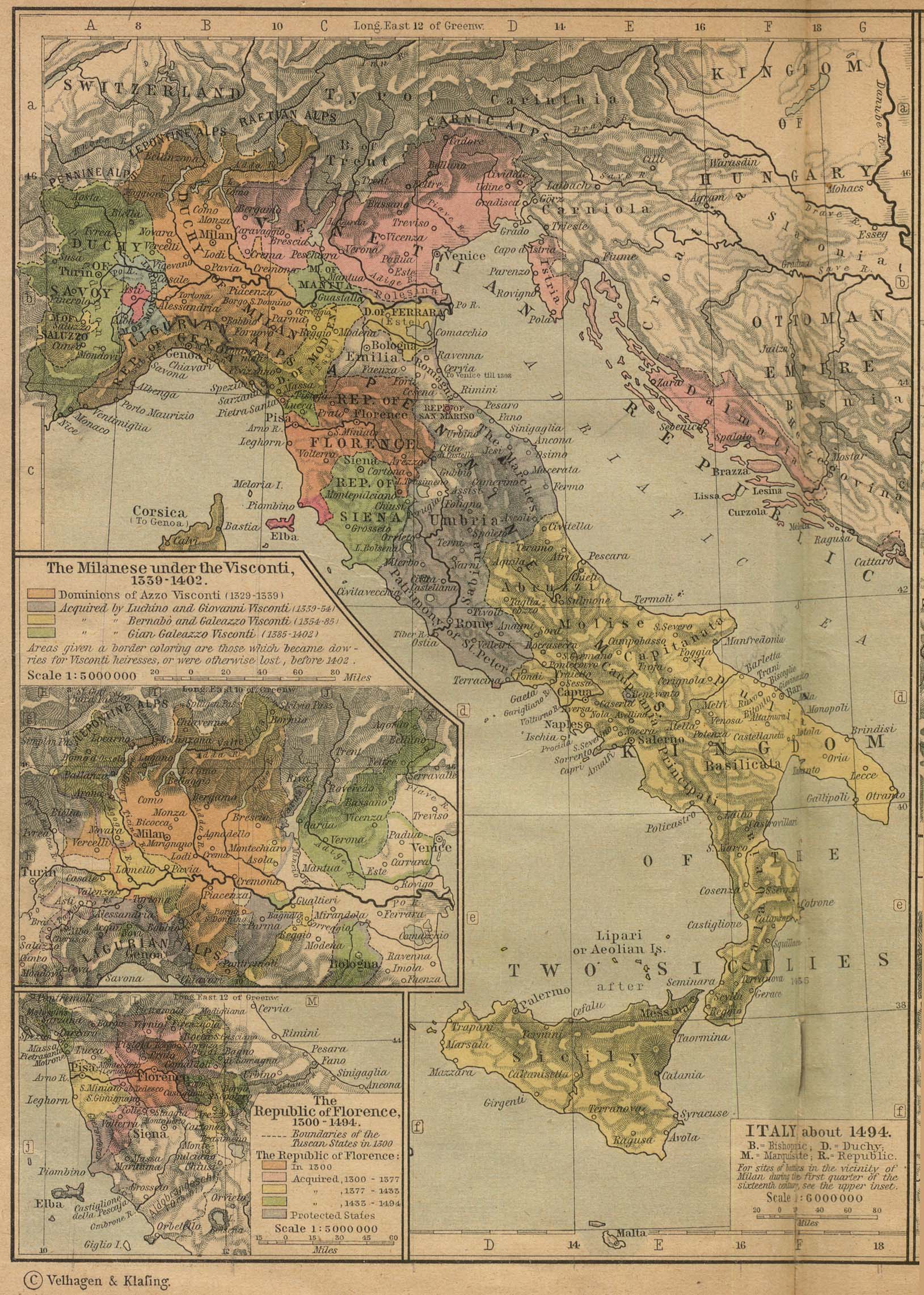
Political map of Italy in early 1494, before the invasion of Italy by Charles VIII of France, created by MapMaster.
Part of a series of maps on the history of Italy:
-
 1000 AD
 -
 1084 AD
 -
 1796 AD
 -
 1810 AD


Versions
[]
PNG:
-
 Arabic
 -
 English
 -
 Greek
Greek


SVG:
-
 French
 -
 Italian
 -
 Hungarian


References
- Bjorklund, Oddvar; Holmboe, Haakon; Rohr, Anders (1970) Historical Atlas of the World, Barnes & Noble, NY, SBN: 389-00253-4.
- Matthew, Donald, (1983), Atlas of Medieval Europe, Checkmark Books, New York.
- Online maps, including this 1882 map from Shepherd (the University of Texas)
- this one from A B Longman, textbook publisher.
Lisensijə
I, the copyright holder of this work, hereby publish it under the following licenses:

|
Haštejədə kopijə karde, pevylo karde ijən/ja ovaxte ym sənədi de šərton GNU Free Documentation License versijon 1.2 ja pešonə gylon, edaštəše Ozodə progrəmmi oko doj fond, be ovaxtə nybə loon, be mətnon, bə iminə ijən oxonə dimkəšədə.
Lisensijə kopijə dəǧandə byə bə lo, nomyš GNU Free Documentation License. |
| Ym fajl dastrəse de lisensijə Creative Commons Attribution-Share Alike 3.0 Unported. | ||
| ||
| This licensing tag was added to this file as part of the GFDL licensing update. |
By lisensijonədə šymə bəzynejon har gylə vyžnije
derivative works
Derivative works of this file: Italy 1494 AD-ar.png
Fajli tarix
Fajli syftə varianti vinde bə taryx/vaxti egətən.
| Tarix/Vaxt | Gədəlijə šikil | Pamjəjon | Ištirokəkə | Komment | |
|---|---|---|---|---|---|
| ysətnə | 05:15, 21 Aprel 2009 | | 1,261 × 1,805 (144 KB) | Capmo | palette reduction to 256 colours |
| 02:04, 15 Aprel 2007 |  | 1,261 × 1,805 (539 KB) | MapMaster | Minor modifications | |
| 20:07, 27 Fevral 2007 |  | 1,167 × 1,642 (471 KB) | MapMaster | Modification suggested by User:Paolo da Reggio | |
| 03:52, 9 Janvar 2007 |  | 1,135 × 1,625 (472 KB) | MapMaster | Political map of Italy in early 1494, before the invasion of Italy by Charles VIII of France, created by MapMaster. |
Fajli oko doj
səhifə oko dojdən ym fajl:
Fajli umumi oko doj
Ym fajl oko doə bejdə by vikijonədə:
- Oko doə bejdə af.wikipedia.org
- Oko doə bejdə azb.wikipedia.org
- Oko doə bejdə az.wikipedia.org
- Oko doə bejdə bg.wikipedia.org
- Oko doə bejdə br.wikipedia.org
- Oko doə bejdə bxr.wikipedia.org
- Oko doə bejdə ca.wikipedia.org
- Oko doə bejdə cs.wikipedia.org
- Oko doə bejdə de.wikipedia.org
- Oko doə bejdə el.wikipedia.org
- Oko doə bejdə en.wikipedia.org
- Pope Alexander VI
- Renaissance
- Italian Wars
- Gonzalo Fernández de Córdoba
- Duke of Ferrara and of Modena
- Italian War of 1494–1495
- List of rulers of Montferrat
- User:MapMaster
- Military history of Italy
- User:Juanpdp/Italy
- User:Bolonium/Renaissance
- Marquisate of Incisa
- Timeline of Niccolò Machiavelli
- Italic League
- Oko doə bejdə eo.wikipedia.org
- Oko doə bejdə es.wikipedia.org
- Oko doə bejdə et.wikipedia.org
- Oko doə bejdə fa.wikipedia.org
Dijə karde končo umumi oko dojdən ym fajli.